
Last month, the website that hosted every edition of the National Climate Assessment went dark, marking another egregious instance of disappeared climate data and resources under the current Trump administration. Within days of this erasure, Texas’s Kerr County saw unprecedented flooding, leaving many dead and injured. The timing of the events–alongside the administration’s recent cuts to the National Weather Service and ongoing evisceration of climate data and resources–prompted some officials and media outlets to ask, what went wrong?
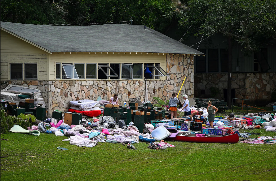
Floods like the one in Texas are “becoming more frequent and intense…as the burning of fossil fuels heats the planet,” according to a recent New York Times report. Kerr County sits in a FEMA designated flood zone along the Guadalupe River and, in the early hours of July 4th, saw the river surge to 26 feet in just 45 minutes. The National Weather Service (NWS) issued a flood watch on July 3rd, highlighting Kerrville–a city located within the county. The NWS upgraded this watch to a flash flood emergency for Kerr County at 4:03 AM, and issued a flash flood warning for Kerrville at 5:34 AM. However, this warning came 45 minutes after gauges along the Guadalupe registered over 23 feet of water. As of recent reporting, the death toll currently stands at 137 people, including more than 35 children.
What exactly led to these historic floods remains unclear. Following the disaster, there are conflicting reports on why the death toll was so high. The BBC points to the natural features of the area, such as where the Guadalupe meets a creak, while a report in Vox notes “gaps in the communication system” that also could be cause for high mortality. In the days after the flooding, an examination by Wired found that the NWS “had performed its job” and that ”the real communication breakdown had happened elsewhere.”
What is clear is that the continued deletion of critical federal data will make these events harder to predict and plan for, and could ultimately lead to disasters elsewhere.
Earlier this year, the National Security Archive published a selection of materials and screenshots detailing the Trump administration’s deletion of environmental information, datasets, and resources. At the time of publication, the White House had removed resources like the Council on Environmental Quality’s (CEQ) Climate and Economic Justice Screening Tool (CEJST); the Environmental Protection Agency’s (EPA) Environmental Topics sections on its homepage; and the State Department’s Climate and Environment and Climate Crisis pages. More recently, the administration has also deleted important climate reports and datasets from agencies like the National Oceanic and Atmospheric Administration (NOAA) and the National Aeronautics and Space Administration (NASA).
The quadrennial National Climate Assessments–which were housed in the now defunct U.S. Global Change Research Program (USGCRP) federal website–detail the effects of climate change across the U.S. and are used by governments, communities, and businesses to make crucial decisions in relation with the assessments findings. Although the USGCRP is statutorily mandated by Congress to study the changes in Earth’s climate and environment, the program had its funding cut in April, a bellwether for the disappearing assessments.
In July, the New York Times reported that the sites contained important information about changes to weather patterns, greenhouse gas emissions, and original maps, all exceedingly important resources for city planners, engineers, and others to use to plan for floods and other climate events. A report from E&E News found that while the weather reports and predictions are accurate today, “weather predictions and forecast accuracy stand to change as Trump cements his agenda.” The growing limitations to publicly accessible weather data and climate information could have disastrous impacts.
Without comprehensive environmental and climate data, local officials, city planners, and communities might struggle to make plans to keep people safe. While the exact cause of the Texas flooding might be inconclusive, the recent disaster highlights the stark reality that less access to accurate climate data keeps us all in the dark.
